http://quoteko.com/haiti-flag-map.html
The Location of Haiti and The Region
The Island of Haiti occupies a third of the western part of the islands of Hispaniola. It is shared with the Dominican Republic. Haiti has an area of 27,750 square kilometers. It is slightly smaller than the state of Maryland. It is just a few hundred miles off the coast of Florida. Dominican Republic shares a border of 275 kilometers and has a coastline of 1,771 kilometers. Haiti’s capital and largest city is Port-au-Prince. Haiti is the poorest country in Western Hemisphere.The population in Haiti is estimated to be 6,867,995 in July of 2000. It grows at a rate of 1.39 percent and rises 36 percent since 1982. At that time the population stood at 5,053,792. The country of Haiti is in a extreme poverty. The conditions of poverty is reduced expectancy to 49.2 years. It also slowed down the population. The population stood at approximately 7 million in 2010. This country is one of the most densely populated countries in the world. It estimated at 270 person per square kilometers in 1997. Its a young population with 41 percent between 0 and 14 in 2000. 95 percent of Haitians populations are defined as black. The remaining 5 percent that is left is comprised as a small descended immigrants from the Middle East. There are three regions in Haiti and they are the northern region, the central region, and the southern region. It also controls several nearby islands.

A chart of the population of Haiti. http://www.faculty.fairfield.edu
/faculty/hodgson/Courses/so191/
Projects2010/Laura_Havill/haiti%20004.png
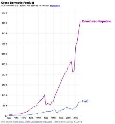
The Poverty of The Country
|
http://www.searchamelia.com/haiti-needs-an-economic-identity-to-survive
Cause of Poverty and Hungry
|
